Ashgabat (Turkmen: Aşgabat, Persian: اشک آباد or عشق آباد, Russian: Ашхабад) is the capital and largest city of Turkmenistan. It has an estimated population of 1 million (2009) and is situated between the Kara Kum desert and the Kopet Dag mountain range. Ashgabat has a primarily Turkmen population, with ethnic minorities of Russians, Armenians, and Azeris. It is 250 km from the second largest city in Iran, Mashhad (Tus).
From 1919 until 1927, the city was renamed Poltoratsk after a local revolutionary. Before 1991, the city was usually spelled Ashkabad in English, a transliteration of the Russian form, which was itself from the original Persian form. It has also been variously spelled Ashkhabat and Ashgabad.
Root of the name of the city goes back to Arshacid Empire era, and derived from the name of the founder of the Parthian Empire, Ashk I. So it seems the original form of the name was Ashk-Abad, and because of Turkish pronunciation of the name it became like it is today.
A folk and inaccurate etymology suggests that the name is a dialect version of the word of eshq (عشق meaning “love”) and Persian ābād (آباد meaning “inhabited place” or “city”, cognate to the English word “abode”), and hence loosely translates as “the city of love” or “the city that love built”.
History
In its current outline, Ashgabat is a relatively young city, growing out of a village of the same name established by Russian officers in 1881. It is not far from the site of Nisa, the ancient capital of the Parthian Empire, and it grew on the ruins of the Silk Road city of Konjikala, which was first mentioned as a wine-producing village in 2nd century BCE and was levelled by an earthquake in 1st century BCE (a precursor of the 1948 Ashgabat earthquake). Konjikala was rebuilt because of its advantageous location on the Silk Road and it flourished until its destruction by Mongols in the 13th century CE. After that it survived as a small village until Russians took over in the 19th century.
In 1869, Russian soldiers built a fortress on a hill near the village, and this added security soon attracted merchants and craftsmen to the area. Ashgabat remained a part of Persia until 1881, when it was ceded to Tsarist Russia under the terms of Akhal Treaty. Russia chose to develop Ashgabat as a regional centre due to its proximity to the border of British-influenced Persia. It was regarded as a pleasant town with European style buildings, shops and hotels.
Soviet rule was established in Ashgabat in December 1917. However in July 1918 a coalition of Mensheviks, Social Revolutionaries and Tsarist former officers of the Imperial Russian Army revolted against the Bolshevik rule emanating from Tashkent and established the Ashkhabad Executive Committee. After receiving some support (but even more promises) from General Malleson, the British withdrew in April 1919, and the Tashkent Soviet resumed control of the city and in July 1919, when the city was renamed Poltoratsk (Полторацк) after a local revolutionary. The name Ashgabat was restored in 1927 after the establishment of Turkmen SSR as a Soviet republic, though it was usually known by the Russian form Ashkhabad (Russian: Ашхабад). From this period onward, the city experienced rapid growth and industrialisation, although this was severely disrupted by a major earthquake on October 6, 1948. An estimated 7.3 on the Richter scale, the earthquake killed 110-176,000 (⅔ of the population of the city), although the official number announced by Soviet news was only 40,000.
Ashgabat milestones
- 1882-1918 – administrative centre of Russia’s Transcaspian Region
- 1918-1925 – administrative centre of the Turkmen Oblast in Turkestan ASSR
- Since February 1925 – capital of Turkmen SSR
- Since October 1991 – capital of independent Turkmenistan
Economy
Ashgabat is primarily a government and administrative centre. The principal industries are cotton textiles and metal working. It is a major stop on the Trans-Caspian railway.
The city is served by Ashgabat Airport. Turkmenistan Airlines has its headquarters in the city.
Ashgabat's urban transport network includes the Ashgabat trolleybus system.
Climate
The Kopet-Dag mountain range is about 25 km to the south, and Ashgabat’s northern boundary touches the Kara-Kum desert. Because of this location, Ashgabat has an arid climate with hot and dry summers and mild and short winters. The average high temperature in July is 38.2°C. The highest temperature on record is 54°C. Night-time temperatures in the summer are warm, with an average minimum temperature in July of 23.1°C. Average winter high temperatures range from 7.4 to 9.8°C, and average lows in the winter of -1.6 to 0.7°C; temperatures as low as -16°C have been recorded in December. Snow is rare. Annual precipitation is only 227 mm; March and April are the wettest months.
Notable buildings
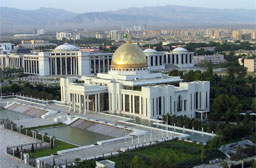
Museums include the Turkmen Fine Arts Museum and Turkmen Carpet Museum, noted for their impressive collection of woven carpets as well as a Turkmen history museum and the Ashgabat National Museum of History, which displays artefacts dating back to the Parthian and Persian civilizations. The Academy of Sciences of Turkmenistan is an important institute of higher learning. Large mosques include the Azadi Mosque, the Khezrety Omar Mosque, and the futuristic Iranian Mosque. Ashgabat was also home to the Arch of Neutrality, a 250-foot-tall tripod crowned by a golden statue of late president Saparmurat Niyazov (also known as Turkmenbashi, or leader of all Turkmen). The 50-foot-high statue, which rotated in order to always face the sun during daylight hours, was removed on August 26, 2010 after Niyazov’s successor, current President Gurbanguly Berdimuhamedov, made it clear earlier in the year that the statue was going to be taken out of Ashgabat’s parliament square.
There are several institutions of higher education, including Turkmen A.M. Gorkii State University (1950) and polytechnic, agricultural, and medical institutes. The Turkmen Academy of Sciences, founded in 1951, includes the unique Institute of Deserts.