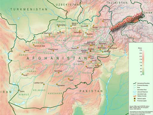
Wakhan Corridor is commonly used as a synonym for Wakhan, an area of far north-eastern Afghanistan which forms a land link or “corridor” between Afghanistan and China. The Corridor is a long and slender panhandle or salient, roughly 220 km long and between 15 and 65 km wide. It separates Tajikistan in the north from Pakistan in the south.
The corridor was a political creation of the Great Game. On the corridor’s north side, agreements between Britain and Russia in 1873 and between Britain and Afghanistan in 1893 effectively split the historic area of Wakhan by making the Panj and Pamir Rivers the border between Afghanistan and the Russian Empire. On its south side, the Durand Line agreement of 1893 marked the boundary between British India and Afghanistan. This left a narrow strip of land as a buffer between the two empires, which became known as the Wakhan Corridor in the 20th century. The corridor has 12,000 inhabitants.
The term Wakhan Corridor is also used in a narrower sense to refer to the route along the Panj River and the Wakhan River (واخان دریا) to China, and the northern part of the Wakhan is then referred to as the “Afghan Pamir”.
The Pamir River, flowing out of Lake Zorkul, forms the northern border of the corridor. The Wakhan River passes through the corridor from the east to Kala-i-Panj, joining the Pamir River to become the Panj River.
In the south, the corridor is bounded by the high mountains of the Hindu Kush, crossed by the Broghol pass, the Irshad Pass and the disused Dilisang Pass to Pakistan.
At the eastern border, the Wakhjir Pass through the Hindu Kush at 4,923 m, is one of the highest in the world.
Although the terrain is extremely rugged, the Corridor was historically used as a trading route between Badakhshan and Yarkand. It seems that Marco Polo came this way. The Portuguese Jesuit priest Bento de Goes crossed from the Wakhan to China between 1602 and 1606. In May 1906 Aurel Stein explored the Wakhan, and reported that at that time 100 pony loads of goods crossed annually to China.
Early travellers used one of three routes:
- A northern route led up the valley of the Pamir River to Zorkul lake, then east through the mountains to the valley of the Murghab River (مرغاب), then across the Sarikol Range (سرقول) to China.
- A southern route led up the valley of the Wakhan River to the Wakhjir Pass to China. This pass is closed for at least five months a year and is only open irregularly for the remainder.
- A central route branched off the southern route through the Little Pamir to the Murghab River valley.
As a through route the Corridor has been closed to regular traffic for over 100 years. There is no modern road through the Corridor. There is a rough road from Ishkashim to Sarhad-e Broghil built in the 1960s, but only paths beyond. It is some 100 km from the road end to the Chinese border at Wakhjir Pass, and further to the far end of the Little Pamir.
Afghanistan has asked China on several occasions to open the border in the Wakhan Corridor for economic reasons, or as an alternative supply route for fighting the Taliban insurgency. However China has resisted, largely due to unrest in its far western province of Xinjiang which borders the corridor.